Washfold
Coordinates: 54°25′23″N 1°54′31″W / 54.42311°N 1.90869°W
Washfold is a hamlet and farm in North Yorkshire, England about 10 miles north west of Richmond. It lies near Hurst, another hamlet.
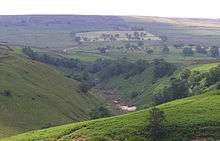
The old workings of Pryes Lead Mine by Shaw Beck, east of Washfold
External links
![]() Media related to Washfold at Wikimedia Commons
Media related to Washfold at Wikimedia Commons
This article is issued from Wikipedia - version of the 1/24/2016. The text is available under the Creative Commons Attribution/Share Alike but additional terms may apply for the media files.